This year, the monsoons in the western Himalayas have been catastrophic. Jammu received its highest rainfall in more than 50 years, while Himachal Pradesh saw its wettest August since 1949.
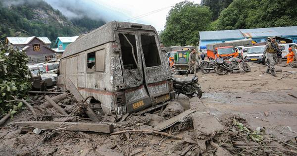
The intense rain has triggered devastating landslides, leaving many dead and damaging property and infrastructure. In Uttarakhand, nine were feared dead after a severe landslide in June. (Excess rain has not been identified as the primary cause of the Dharali disaster in August.) In Kishtwar in Jammu and Kashmir, a heavy spell of rain in August killed at least 64 people. In Himachal Pradesh, the monsoons have claimed a total of 343 lives so far.
Broader data also makes clear how extreme this rain has been. Between June and August, north-west India, which includes Himachal Pradesh, Uttarakhand and parts of the Jammu and Kashmir, as well as Haryana, Punjab, Rajasthan and parts of Uttar Pradesh, received 23% more than the average rainfall of these months between the years 1961 and 2010.
The disasters that have unfolded in the region in recent weeks are often seen as isolated incidents. But a deeper examination of climate patterns in the region and beyond reveals that a complex cocktail of broader forces are at play. Specifically, the confluence of warming temperatures in both the highest ranges of the Himalayas and in the Indian Ocean, particularly in the Arabian Sea, has been a key factor in the intensified rainfall.
Climate experts and geologists note that unless the government takes these changing climate patterns into account, and draws up strategies to protect the region from their effects, vast numbers of people will continue to remain vulnerable to deadly forces of weather.
For now, experts suggest that there is very little to indicate the government is treating the problem on the scale that is needed.
“On the contrary, we have made the Himalaya more vulnerable through road excavation, hydropower, pluralification of settlement along rivers, and tunnelling activity of railways, impacting its inherent fragility,” said Navin Juyal, a scientist who has worked on the long-term impact of climate change on the Himalayas.
Rising temperatures, warming oceans
Soumya Dutta, a visiting senior fellow at Delhi’s Impact and Policy Research Institute, who works on energy and climate, noted in an online panel discussion in August that between 1995 to 2024, the trans-Himalayan region, which refers to the higher altitude northern part of the range, had seen a temperature rise almost 1.5 times greater than the increase in central and peninsular India.
This rise had led to the formation of a low-pressure zone in the region, Dutta noted, which “pulls the monsoon more towards the Himalaya. In the last few years, it has increased this tendency a lot.”
The warming of the Arabian Sea, an apparently unconnected and distant phenomenon, has also played a key role in the increased rainfall in the Himalayas.
The branch of monsoon winds that flow over the Arabian Sea gather moisture along the way – this moisture causes rainfall on the western coast. Similarly, winds flowing over the Bay of Bengal are responsible for rainfall on the eastern coast. “The Arabian Sea contributes the most to the summer monsoon, about 70%, while the Bay of Bengal contributes about 30%,” said Dutta.
Between 1982 and 2019, the temperature of the Arabian Sea has increased steadily – each decade, it has seen roughly 20 more marine heatwave days than the previous one.
“Rapid warming of the Indian Ocean, especially the Arabian Sea, is loading the monsoon with more moisture,” explained Roxy Mathew Koll, a climate scientist at Pune’s Indian Institute of Tropical Meteorology. Koll explained that when these moisture-rich winds hit mountain ranges over the Indian subcontinent, the result is short, high-intensity rain over small catchment areas.
“Our work shows widespread extreme rainfall over India has roughly tripled since the 1950s, consistent with this moisture-surge mechanism,” he said.
Experts worry that populations in the western Himalayan region are particularly vulnerable to these changes – even more so than those in the eastern parts, such as in the north-eastern states.
“Eastern Himalaya has a higher tree cover and its vegetation is very thick, except in the glacial areas,” Dutta said. He explained that this thick vegetation can help arrest landslips and landslides. “If there is a lot of rain, while eastern Himalaya will also face damage, the impact will be more in western side,” he noted in the online discussion, in response to a question from Scroll.
The role of Western Disturbances
This year, rain in the western Himalayas was further intensified by active Western Disturbances. These are tropical storms that originate from the Mediterranean Sea and travel east across Iran, Afghanistan, and Pakistan before reaching north-western parts of the country and the Himalayas, bringing rain and snow to them.
Usually, these storms are active in the winter months, with around four or five occurring monthly between December and February. But according to an analysis of meteorological data by Down to Earth, as of August this year, there had already been 15 Western Disturbances.
The interaction of these disturbances with monsoons can create havoc. “This is what happened in 2013 floods in Kedarnath,” said Juval.
That year, the movement of a Western Disturbance from west to east, “coupled by the strong moisture feeding from the Arabian Sea and Bay of Bengal triggered heavy rainfall activity over the north Indian region”, a 2017 study by the Indian Meteorological Department stated.

A similar pattern seems to have occurred this monsoon. One of the conditions that the department attributed to the exceptionally heavy rainfall in late August across Haryana and Jammu was the movement of two Western Disturbances over North India. They found that the second of these “became active and interacted with the monsoonal system” to create stronger winds in Haryana and Jammu.
Scientists claim that the changes in the Western Disturbances are in turn a result of changes in winds known as “subtropical jets” – these fast-moving, high-altitude winds typically control the development and movement of the Western Disturbances throughout their path.
Earlier, these jets receded northwards and away from India by May, easing the conditions that created Western Disturbances over north India. But this retreat has seen a shift in its pattern. A 2024 study that analysed data for 70 years found that in the last 20 years, Western Disturbances had become twice as common in June than in the previous 50 years. Thus, these winds are now more likely to remain over northern India and Pakistan as the monsoon develops.
“Now, climate models are suggesting that this kind of coupling of two weather systems will increase with global warming, which means that such events of intense rainfall will also increase,” said Juyal, who was part of a high-powered committee formed by the Supreme Court to investigate the impact of the 2013 Kedarnath disaster on the region, as well as another to examine the effects of the widening of the Char Dham road.
Juyal and two other members of the latter committee split from the main group after a dispute on the questioning of the road’s widening. Based on their concerns about climate and ecology, this minority committee recommended that roads in Uttarakhand should not be widened beyond 5.5 meters – ignoring this recommendation, the government has proceeded with the construction of roads that are 10 metres wide.
“Our study was overruled,” Juyal said. “The result is in front of you.”
This article first appeared on Scroll.in
📰 Crime Today News is proudly sponsored by DRYFRUIT & CO – A Brand by eFabby Global LLC
Design & Developed by Yes Mom Hosting