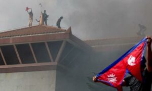
On 8 July, floodwaters surged into the Bhote Koshi River along the Nepal-China border. At least nine people in the Nepali village of Rasuwagadhi were killed and dozens went missing. A major bridge connecting Nepal to China was swept away. The trigger for this devastating flood? A newly formed small lake on top of a glacier that was not visible before March this year.
Glacial lake outbursts are known to cause devastating floods, but these have typically been from larger and more well established lakes. Now, experts are finding that “tiny and short-lived glacial lakes are becoming more hazardous than previously perceived”, said Finu Shrestha, a remote sensing and geo-information analyst at the International Centre for Integrated Mountain Development – ICIMOD.
Among other reasons, the inability to monitor changes hidden beneath the surface of small glacial lakes means their potential impacts remain undiscovered. Further, when the lakes drain, even small releases can have big impacts downstream due to debris, the shape of river channels and other factors.
Fast forming, sensitive
What happened at Rasuwagadhi is not the first case of a glacial lake outburst flood from a smaller lake. In August 2024, a flash flood struck Thame village in eastern Nepal’s Solukhumbu district, in the Everest region, following a GLOF from Thyanbo Lake measuring only 0.05 sq km. This destroyed infrastructure downstream and displaced at least 135 residents.
More recently, in May 2025, two glacial lakes burst above Tilgaon, a village in north-western Nepal’s Humla district. That triggered a destructive flood and subsequent landslide which damaged local infrastructure including bridges and electricity lines. Two months later, a tiny ice-dammed lake in central Nepal’s Upper Mustang, of just 0.016 sq km, burst and sent floods rushing up to 35km downstream, destroying four bridges.
ICIMOD experts who spoke to Dialogue Earth said smaller lakes – in some cases too small to be visible in satellite imagery – have generally been seen as less hazardous partly due to their seasonal nature and relatively low and steady release of water.
But recent floods show the impact of a GLOF cannot be predicted based on lake size or water volume alone, said Sudan Bikash Maharjan, another remote sensing analyst at ICIMOD. Downstream factors that can exacerbate impacts include the presence of sediment from previous landslides and floods, and natural and human-made changes to the landscape.
“Complex interactions can amplify or reduce the extent of damage, meaning even small lakes can pose serious risks under certain conditions.”
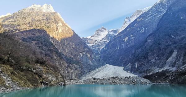
The flood in Rasuwagadhi is one such example. ICIMOD’s time series data shows the formation and draining of a glacial lake at the Purepu Glacier, about 35km upstream, over a week in July 2023. The lake widened again in December 2024, and grew even more significantly in June 2025.
According to Maharjan, the satellite imagery shows that the flood from the July 2023 draining only travelled about 10km downstream back then. But just two years later, flooding from the expanded lake would go on to impact areas over 100km downstream, killing at least 11 people and leaving 17 missing.
ICIMOD noted that the GLOF impacting Rasuwagadhi may have been sediment-laden. Such debris can cause more destruction to infrastructure and potentially change the shape of downstream river channels.
GLOF risk also differs depending on the type of lake, Shrestha explained. Large glacial lakes, typically forming near glacier termini and dammed by loose moraines, are especially vulnerable to sudden destabilisation from external triggers and physical disturbances. These may be avalanches, rockfalls or ice calving – the breaking of chunks from glacier edges – which can trigger catastrophic floods.
For instance, the outburst of South Lhonak Lake in Sikkim, which covered around 1.66 sq km in October 2023, killed 55 people and caused massive infrastructural damage, including the collapse of the 1,200 MW Chungthang Dam.
In contrast, smaller supraglacial lakes, which form on the glacier’s surface, are less exposed to such external disturbances. They tend to fail due to hidden, internal changes within the glacier system, though both large and small lakes can burst if water volume and pressure build up significantly, Shrestha noted.
Rising temperatures mean supraglacial lakes are forming quickly and expanding in the Hindu Kush Himalayan region as the ice beneath the debris-covered glaciers melts at an accelerated rate. The region already has at least 47 potentially dangerous glacial lakes in Nepal, China and India.
Difficult to detect
Both Shrestha and Maharjan note there are multilayered challenges in detecting small supraglacial lakes and mitigating the impact of any resulting GLOFs.
The speed with which they can drain makes them hard to identify. Even when detected, the rapid changes in their size and merging patterns make it harder to determine the lakes of greatest concern for flooding. “There can be thousands of such lakes scattered across the glacier surface. Without clear signs of rapid growth or merging [of smaller lakes], it’s challenging to identify which lakes pose a serious threat,” notes Shrestha.
Another issue is that satellite imagery can only help if the resolution of available data can distinguish smaller lakes clearly, especially in the presence of snow or cloud cover. The monsoon season, in particular, limits visibility from satellites when these lakes are most active, said Maharjan. These lakes typically form during the summer monsoon, which is also the peak melting season – a time when the region is mostly covered by clouds, with persistent rainfall and snowfall.
While radar-based remote-sensing systems can penetrate cloud cover, they also face limitations on steep mountainous terrain due to issues like signal distortion and the radar sensors’ line-of-sight constraints. Meanwhile, medium-resolution satellite imagery like Landsat, although made freely available, lacks the detail needed for reliable detection of the small features that distinguish these lakes from surrounding features, Maharjan noted.
Additionally, small lakes often form in high altitude regions, and this remoteness makes in-situ monitoring challenging and logistically expensive. “It is not feasible to install and maintain monitoring equipment, such as automatic weather stations, time-lapse cameras, or UAVs [unmanned aerial vehicles] on every glacier across the region,” said Shrestha. As a result, there is a lack of monitoring of such lakes and early-warning systems to provide timely risk alerts.
Shrestha emphasises the importance of regular, year-round mapping of glacial lakes through high-resolution satellite images as a first step in mitigating GLOFs. She also makes a case for leveraging artificial-intelligence-based technologies to detect and map glacial lakes on an annual or even seasonal basis, track their dynamic changes over time, and potentially identify lakes that may pose a future threat.
But all of this requires adequate and sustained investment in establishing, operating and maintaining monitoring stations and early warning systems, she said.
Transboundary cooperation
Shrestha also highlighted that as “GLOFs do not recognise borders”, there is a need for transboundary cooperation to monitor and reduce potential threats from unstable glacial lakes in upstream areas. Joint efforts across the Himalayan countries can support data sharing, enable real-time monitoring, strengthen early-warning systems, and build regional and local capacity in remote sensing and field-based monitoring.
“But regional cooperation in data sharing and early warning is still insufficient in addressing the growing risks posed by rapidly forming glacial lakes,” said Shrestha. One key challenge is the absence of strong institutional collaboration between neighbouring countries. While there are some bilateral or regional initiatives in place, they are often informal, inconsistent or limited in scope.
“In many instances, governments are reluctant to share real-time hydrometeorological and risk data across borders due to political sensitivities, security concerns or trust issues,” she said.
There is much at stake. The unpredictability and increasing frequency of GLOFs make them a growing threat for communities living downstream, who bear the brunt of impacts such as sudden displacement, infrastructure loss and disrupted livelihoods, Shrestha added.
She added that awareness among local communities is still lacking, “particularly regarding newly forming or small supraglacial lakes”. Many residents remain unaware of changing conditions upstream and lack access to timely or accessible information about lake formation and expansion, Shrestha explained.
Both experts highlighted that without better monitoring, regional cooperation and local education, even tiny lakes can cause devastation. Bridging the gap between scientific monitoring and local-level risk communication becomes critical, they noted.
Shalinee Kumari is Dialogue Earth’s South Asia editorial assistant, based in New Delhi.
This article was originally published on Dialogue Earth under the Creative Commons BY NC ND licence.
📰 Crime Today News is proudly sponsored by DRYFRUIT & CO – A Brand by eFabby Global LLC
Design & Developed by Yes Mom Hosting