A new study published in Nature Sustainability warns that India’s largest cities are slowly sinking. Using eight years of satellite radar data, researchers found that parts of Delhi, Mumbai, Chennai, Kolkata and Bengaluru are subsiding due to groundwater extraction and soil compaction, a process where the ground compresses as water is drawn out from underground layers.
Land subsidence, or the gradual sinking of the ground, occurs when underground water is pumped faster than it can be naturally replenished, causing soil and rock layers to compress.
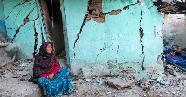
The study mapped 878 square kilometres of land showing signs of subsidence and found that nearly 1.9 million people are exposed to areas where the ground is sinking faster than 4 millimetres each year. More than 2,400 buildings across Delhi, Mumbai and Chennai are at high risk of structural damage from ongoing land subsidence.
City-level projections show that Chennai and Delhi could be the worst affected, followed by Kolkata, Mumbai, and Bengaluru. The paper projects that more than 23,000 buildings could face a very high risk of structural damage within the next 50 years if current trends continue.
Although less than 5% of urban areas fall under high-risk zones, these tend to be densely populated neighbourhoods, making the potential damage disproportionate.
“Our motivation to study land subsidence and building damage risk in Indian megacities stems from the absence of prior research that explicitly investigates land subsidence and links differential settlement with observed structural damage,” Nitheshnirmal Sadhasivam, a PhD researcher in geosciences at Virginia Tech and a co-author of the paper’s told Mongabay-India.
“While the impact of land subsidence on infrastructure is a well-recognised geohazard globally, in cities such as Jakarta, Mexico City and Tehran, its implications for building stability in India have not been systematically assessed.”
The study used a geotechnical measure called angular distortion (the degree to which one part of the ground tilts or sinks compared to another) to identify where buildings are most likely to develop cracks or stress.
This measure captures how unevenly the ground beneath a structure settles. Even minor differences in settlement between adjacent areas can cause strain that weakens foundations over time.
Hotspots and the case of Dwarka
The study shows that Delhi and Chennai face the most worrying levels of subsidence. In Delhi, the fastest-sinking zones are located near Bijwasan, Faridabad and Ghaziabad. In Chennai, the Adyar river floodplain and neighbourhoods such as Valasaravakkam, Kodambakkam, Alandur and Tondiarpet are the most affected.
In Mumbai, while subsidence is lower than in Delhi or Chennai, poorer neighbourhoods such as Dharavi, Sangam Nagar, Shivaji Nagar and others were found to be sinking faster than more affluent localities, said the researchers. Researchers say the concentration of informal housing and thinner foundations exacerbate both the dependence on groundwater and the structural risks.
“Across all five megacities, groundwater dependence and overexploitation emerge as the dominant local drivers of subsidence,” said Sadhasivam. “As groundwater is withdrawn, the resulting loss of pore pressure in compressible aquifer layers causes gradual compaction, leading to measurable land surface sinking over time.”
Dwarka in southwest Delhi showed signs of recovery. Groundwater recharge programmes and restrictions on extraction helped stabilise the ground after years of decline.
“Regions like Dwarka in Delhi demonstrate that policies promoting groundwater regulation and artificial recharge can help stabilise the ground and partially reverse subsidence trends,” Sadhasivam explained. “However, recovery is not always uniform. When some areas experience uplift while adjacent zones continue to subside, sharp gradients in ground motion result, creating transitional stress zones.”
Artificial recharge refers to methods such as rainwater harvesting or recharge wells that help water percolate back into depleted aquifers.
Dwarka’s experience highlights how rainwater harvesting and recharge wells can help slow the rate of sinking.
Vikas Kanojia, an urban designer, told Mongabay-India that Delhi’s rapid growth and groundwater decline make it particularly vulnerable if the sinking continues. “The National Capital Region is quite vulnerable to land subsidence with the current progression of depleting ground water and increase in population,” he said. “It would possess a threat not only to human life but also to the natural and built heritage, flora and fauna, buildings, flyovers, highways etc.”
He said Delhi’s fast urban expansion has outpaced groundwater recharge, changing the density and strength of sub-soil layers. “Many zones in NCR [National Capital Region] are facing water shortage due to deficient ground water recharge versus demand,” he said. “The ground water table has drastically dropped in many areas of NCR leading to change in the density of the sub-soil structure.”

Compounding urban hazard
Land subsidence interacts with other urban risks such as flooding and earthquakes, amplifying the impact on already overburdened infrastructure.
“When the ground sinks, it alters drainage patterns, lowers surface elevation and reduces a city’s natural capacity to discharge floodwaters, making even moderate rainfall events more damaging,” Sadhasivam said. “In earthquake-prone regions, uneven ground settlement weakens a building’s ability to absorb seismic forces.”
Climate scientists agree that the problem is far more than a local engineering issue. M Rajeevan, Vice Chancellor of Atria University and former Secretary of the Ministry of Earth Sciences, said land subsidence adds a new dimension to India’s growing climate vulnerability.
“The present paper documents a grave situation of land subsidence in Indian cities. Already, the Indian coastal cities are vulnerable to flooding and coastal vulnerability due to sea-level rise and increasing intensity of tropical cyclones. The land subsidence is another dimension of vulnerability of Indian cities,” he said.
Rajeevan warned that the problem is also acute in inland areas such as Delhi, which are built on soft alluvial soil and face rapid groundwater depletion. “Delhi should be more prone for land subsidence because Delhi and surrounding region, like Punjab and Haryana, is witnessing massive groundwater stress due to over-extraction of ground water mainly for agriculture,” he said.
He added that heavy rains and flash floods can worsen the problem. “Flash floods due to heavy rains can take away top soil and make loose soil and land subsidence. The buildings in cities otherwise are vulnerable due to flash floods,” Rajeevan said.
What the ground reveals
The study’s findings have also sparked debate among hydrogeologists about the complexity of causes behind subsidence.
Hydrogeologist KM Namboodiri, who was not associated with the study, said the causes of subsidence are complex and vary depending on local geology. He emphasised that it cannot be explained by groundwater extraction alone.
Namboodiri noted that, except in Delhi, the study does not provide direct evidence of a link between groundwater extraction and subsidence. He said local geological studies would be needed to confirm the causes in each city.
“Land subsidence is a multi-causative phenomenon,” Namboodiri said. “The major contributing factors are excessive unit load applied, uneven spatial distribution of vertical loading, bearing capacity of the soil, and the structure, grain size distribution and the level of saturation and the bearing capacity of the underlying strata.”
He explained that Delhi’s alluvial formations, made up of alternating sand, clay and gravel, are particularly prone to settlement when the water table drops quickly. “If the drawdown is very fast, a phenomenon called ‘piping’ takes place, leaching finer particles into the bottom layer. Both these processes disturb the soil equilibrium and cause differential settlement [uneven sinking of the ground beneath different parts of a building]. This is what is happening in Delhi,” he said.
Piping refers to the movement of fine soil particles through underground water channels, which can create voids and make the ground unstable.
In contrast, he noted, hard-rock aquifers in places like Bengaluru or Coimbatore have higher bearing capacity and are less affected by extraction. “In hard rock or fractured aquifer regions, the bearing capacity of the formations is very high and aquifer emptying does not impact the bearing capacity of the soil and thus little or no subsidence occurs,” Namboodiri said.
In hard-rock regions, water is stored in cracks and fractures deep underground, while in alluvial areas like Delhi, it sits in loose sand and clay layers that compress more easily.
He added that coastal cities such as Chennai and Mumbai behave differently because seawater replenishes the aquifers. “Unless it is an isolated aquifer, one cannot create an unsaturated underground zone because it gets filled immediately up by sea water. Probably this is the reason for the steady water table in Chennai and Mumbai,” he said.
Kanojia said unorganised urbanisation is weakening the city’s ecological systems, aggravating both flooding and land instability.
“The lifeline of every city is its ecological system which comprises landforms, protected forests, hydrological systems such as rivers, rivulets, lakes, ponds, aquifers and wetlands,” he said. “Unorganised urbanisation destabilises this ecological network, which leads to natural disasters like land subsidence and flash floods.”

Building for the future
The authors of the study recommend that India’s building codes and city planning systems evolve to address subsidence risk. While the National Building Code, 1970 includes provisions for foundation safety in new construction, it does not yet account for long-term ground deformation.
Experts note that India’s building regulations focus mainly on soil stability during the design and construction phase, with little provision for long-term monitoring of ground deformation. Once projects are completed, there are no formal mechanisms to track gradual sinking or foundation stress, leaving most urban infrastructure unmonitored.
“Periodic post-construction checks through satellite-based deformation monitoring and integration of settlement data into zoning and permitting could help planners anticipate risks before visible distress occurs,” Sadhasivam said.
He said that upcoming NASA-ISRO NISAR (NASA–ISRO Synthetic Aperture Radar) satellite mission, expected to launch in 2026, could transform how India tracks land deformation. Using radar imaging that can detect millimetre-scale ground movement, NISAR will allow scientists to monitor urban sinking almost in real time.
Kanojia emphasised the need to integrate ecological sensitivity into city planning. “Planning of towns and cities should be done with utmost priority to the ecological footprint of the region,” he said. “Hydrogeology studies should be conducted to identify areas which may be vulnerable to land subsidence.”
Scientists say this could help planners detect early signs of stress before visible cracks or collapses appear. “With its frequent revisit time and high spatial resolution, NISAR will make nationwide, cost-effective and consistent monitoring of land deformation possible,” Sadhasivam said. “This will enable Indian cities to transition from reactive disaster response to predictive resilience planning.”
Rajeevan also called for better integration of data into early warning systems. “We need to develop early warning systems for such disasters. Both land and satellite-based observations need to be assimilated into hydrological models to prepare early warnings. Satellite observations particularly targeting the needs of major cities could be very useful,” he said.
An urgent policy wake-up call
Scientists and hydrogeologists agree that India’s cities can no longer ignore what is happening beneath their foundations.
As Rajeevan put it, “Many policy makers are not aware of this mega problem. Our cities were built with little thinking on these issues, but we still have time to change our policies to reduce vulnerability. Land subsidence could be another dimension of the urban disasters India already faces.”
Rajeevan said that many Indian cities were planned without considering long-term land stability, making it urgent to integrate ground deformation into climate and infrastructure policies.
Scientists say the way forward lies in combining groundwater governance, flood management, and satellite-based monitoring to protect infrastructure and lives in a rapidly urbanising nation.
Kanojia added that involving communities in restoring water systems can help reduce long-term risks. “Community participation led development to rejuvenate the water system would not only help in building awareness towards the land subsidence issue but also help people reconnect with their city’s natural systems,” he said.
This article was first published on Mongabay.
📰 Crime Today News is proudly sponsored by DRYFRUIT & CO – A Brand by eFabby Global LLC
Design & Developed by Yes Mom Hosting